Page 34 - FDS Annual Report 2009
P. 34
FOREST DEPARTMENT SARAWAK
ANNUAL REPORT 2009
9. WEB-GIS Application
During the year, the Department developed the Web PEC-GIS application, integrating Royalty
Billing System and Geographical Information System.
10. Hyperspectral Sensing Program (Technology Applications for Natural Resource
Assessment)
The objective of acquiring
hyperspectral sensing program in
2009 (high fidelity airborne sensors)
under the 9 Malaysia Plan was to
th
derive detailed forest cover
parameters such as for the
production of baseline data (Forest
Cover) for the HoB project, Sarawak.
The program was initiated through
the collaboration with Spectral
Imaging (SPECIM) of Finland for the development of the Airborne Hyperspectral Imaging
System (AHIS) which is a turnkey aerial hyperspectral imaging system. For the sensor
operations and development of applications related to the use of such technology, the
department has built upon its own local in house expertise.
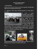
(Left) The crew and hyperspectral image processing facility at Forest Department Sarawak.
(Right) Airborne sensor components and training of sensor operator.
30 | P a g e
ANNUAL REPORT 2009
9. WEB-GIS Application
During the year, the Department developed the Web PEC-GIS application, integrating Royalty
Billing System and Geographical Information System.
10. Hyperspectral Sensing Program (Technology Applications for Natural Resource
Assessment)
The objective of acquiring
hyperspectral sensing program in
2009 (high fidelity airborne sensors)
under the 9 Malaysia Plan was to
th
derive detailed forest cover
parameters such as for the
production of baseline data (Forest
Cover) for the HoB project, Sarawak.
The program was initiated through
the collaboration with Spectral
Imaging (SPECIM) of Finland for the development of the Airborne Hyperspectral Imaging
System (AHIS) which is a turnkey aerial hyperspectral imaging system. For the sensor
operations and development of applications related to the use of such technology, the
department has built upon its own local in house expertise.
(Left) The crew and hyperspectral image processing facility at Forest Department Sarawak.
(Right) Airborne sensor components and training of sensor operator.
30 | P a g e